


Sudan Launches First Artificial Satellite, SuSat1
24 November, 2019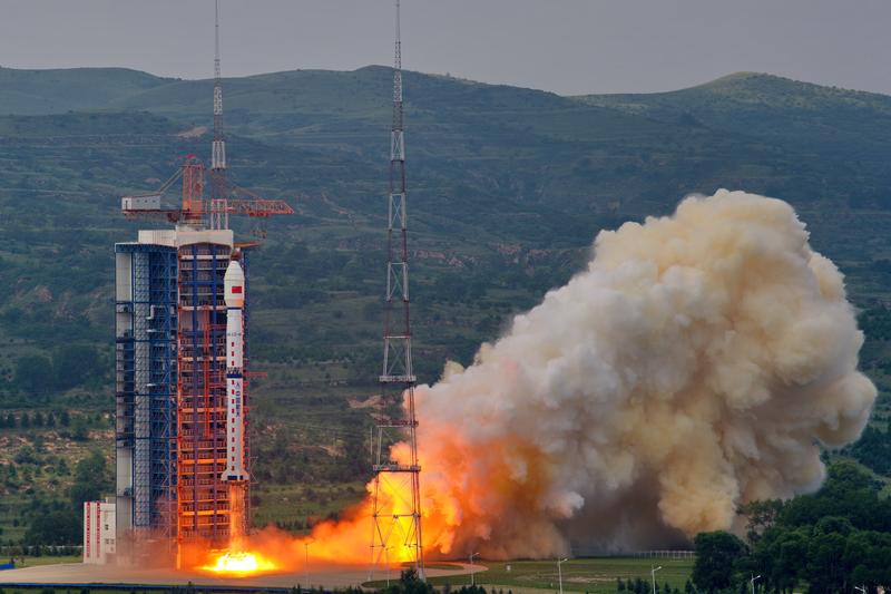
KHARTOUM (Sudanow) - Sudan has recently launched its first space satellite from the Taiyuan Satellite Launch Center in north China's Shanxi Province, announced Member of the Transitional Sovereign Council, Mohammad Alfaki Suleiman in a brief statement.
Suleiman said the SuSat1 (an acronym of the name Sudanese Satellite 1) reached its orbit successfully.
By that Sudan has joined the club of states having satellites in the outer space.
The move is part of a comprehensive plan to promote the country’s capabilities in this domain that in 2013 saw the launch of a space research center.
Sudan’s artificial satellite project started in 2017 and was completed by joint Sudanese-Chinese effort with respect to design, manufacturing and tests. It was achieved under the supervision of the Sudanese Space Agency that comprises all related government and scientific bodies.
The satellite weighs an overall 16 kilograms with a photo precision of five meters @ 500 kilometers. It rotates at an orbit of 530 kilometers above the earth.
It is classified among the category of remote sensing satellites and is designed to serve both military and civilian purposes.
It has a projected life span of two years, an indication that it is a pilot project aimed at obtaining know-how and expertise in outer space research and at establishing a data base.
Another objective of the satellite is to unveil natural resources and to serve military purposes in a world that depends on open sources in obtaining and utilizing accurate information.
In this respect differentiation is necessary between satellite technology and its uses. The first is confined to a few countries that monopolize this technology and the launching of satellites in the outer space, while the second (the use of this technology) is open to all who want it. Some countries lease their satellites for those who want this service, be they countries, corporate or even individuals.
For that reason, Defense Industries Group of Sudan has established a ground base north of Khartoum to manage the satellite, which will be under full control of purely Sudanese cadres two months after it reaches its orbit.
A good sign is that the early pictures shot by SuSat1 have indicated it was operating in a good manner, a signal that Sudan and China will change hands on the satellite at the fixed date (two months), as referred to above.
The cadres assigned to manage the satellite are all of them below 35 years of age. They received guided education and their graduation researches were related to satellite science. After their graduation, they were sent on scholarships to universities and institutes to obtain MSc and PhD degrees in established countries in this domain. One would find one of them who has obtained an MSc in space engineering from Turkey while another has obtained a doctorate degree from Kyoto Institute of Technology in Japan or elsewhere in the world.
The Satellite is owned by the Series Company, an affiliate of the Defense Industries Group of Sudan.
Series is engaged in the development of different technological apparatus.
This satellite is Series’ maiden product, albeit it was designed and constructed in the People’s Republic of China, though in association with Series researchers.
The satellite is planned to provide a lot of information needed for the country’s development as it makes available pictures for the agricultural sector with respect to the volume of output as compared with the areas projected for cultivation. It also provides maps for irrigation works and the volume of ground water. It also provides maps for specifying the locations and quantities of minerals.
Uses of Artificial Satellites
According to use, artificial satellites are classified into these categories:
The biosatellites, the weather satellites, the military satellites, the communication satellites, earth observation satellites and navigation satellites.
-The biosatellite is an artificial satellite designed to carry plants, foods or animals in the outer space. They are used to research the effects of space (cosmic radiation, weightlessness, etc.) on biological matter while in orbit around a celestial body. The idea here is to see the effect of the outer space environment on humans who are planned to go there.
-The weather satellite is a type of satellite that is primarily used to monitor the weather and climate of the earth.
Satellites can be polar orbiting, covering the entire earth asynchronously, or geostationary, hovering over the same spot on the equator.
Of late international weather stations have emerged that produce precise weather maps that can forecast the weather weeks ahead.
-A military satellite is an artificial satellite used for a military purpose. Its most common missions are intelligence gathering, navigation and military communications. By that definition, these satellites monitor the enemy’s movements and give early warning before the enemy opens rocket fire.
-Communications satellites are commonly used for mobile phone signals, weather tracking, or broadcasting television programs and internet service.
-An Earth observation satellite or Earth remote sensing satellite is a satellite used or designed for Earth from orbit, similar to spy satellites but intended for non-military uses such as environment monitoring, meteorology, map making etc.
-Navigation Satellite is used for navigation purposes through the monitoring and direction of vessels in high seas. It helps the vessels determine the earth’s latitudes and altitudes. This helps the ships with accurate positioning in order to keep steering to their required ports of call.
History of Artificial Satellites
The first occurrence of satellite remote sensing can be dated to the launch of the first artificial satellite, Spotnik1 was aired by the Soviet Union on October 4, 1957. Sputnik 1 sent back radio signals, which scientists used to study the ionosphere. NASA launched the first American satellite, Explorer 1 in January 31, 1958.
After the launch of Spotnik 1 by the Soviet Union in 1957, nations of the world raced to send satellites into the outer space, culminating to over 13.000.
However, the satellites now in action are about an only 3500, due to the fact that the rest of the other satellites might have become obsolete or simply malfunctioned for one reason or another. Some of those satellites had deviated from their orbits.
Member nations of the artificial satellites club now number 80, up from 6 in 1966. This indicates the huge progress in this technology and the role artificial satellites play in the world of today.
No doubt, the world’s big powers have the lion’s share in this arsenal of artificial satellites. Some 976 of the total sum of active satellites are owned by the five major countries of the world where the United States of America owns 568, China 177, Russia 133, Japan 56 and the United Kingdom 42 satellites.
The African and Arab nations did not lag far behind in this industry, though with a wide difference in terms of quantity and quality. At the forefront of these we find the Kingdom of Saudi Arabia that owns 16 satellites, having launched its first such facility in 1985. The United Arab Emirates follows with 10 satellites. Each of the Republic of South Africa, Nigeria and Egypt owns 6 satellites. Morocco owns 2 satellites. Each of Qatar, Ghana, Libya, Ruanda and Angola owns one satellite.
National Recommendation
In the world of today, where nations depend on open sources to obtain quick, precise, genuine and inexpensive information, the obtaining of artificial satellites has become imperative. One other advantage of these satellites is that they are difficult to jam or destroy.
All these conditions are available in artificial satellites. That explains the rush on the part of most nations to depend on these facilities to obtain information and fill a void that can be filled by other nations. This notion is best explained by the assertion by Dr. Hussein Alshafe’e, consultant of the Russian space agency in Egypt, who argues that: “if we learn that there are 124 satellites watching Egypt from above for the interest of foreign intelligence agencies, then Egypt should have 20 satellites to guard its borders.”
Thus the case, we in the Sudan with neighboring countries double those of Egypt and with a borderline three folds of that of Egypt, are in more need for such facilities. It could also be noted that the skies of Darfur swarm with 25 spy satellites. For these reasons we deem it essential for anybody who rules Sudan to begin where SuSat1 may stop. In this we have to emulate the late Pakistani ruler Zulfikar Ali Bhutto who set the course and those who followed him completed Pakistan’s ambition of obtaining a nuclear bomb. The Pakistanis were well aware that this was a national project where everybody should do what he can. The SuSat1 is not a certain government’s project that should be dumped when that government is gone.
E N D
YH/AS
Photo of the Week
Everybody alive today came from one African country (The Independent) Ariana Baio Khartoum, Jan.1 (Sudanow)-It is well known that all humans alive today can be traced back to a common ancestor but a study may have found where that ancestor originates. Researchers at the University of Oxford’s Big Data Institute mapped the entirety of genetic relationships among humans t...
More-

01 January, 2023
Phone battery killed nine persons, injured twelve
Zalingei, Jan.1 (Sudanow) - A dispute over a phone battery, in Marin Market, Central Darfur, led to the killing of nine persons and injuring of another twelve. The Director of Central Darfur Police, Salah Omar Al-Tayeb told SUNA last Thursday that main reasons behind the events in Zalingei began with a dispute over a phone battery, where one of the citizens stabbed to death. The police official added that the police forces moved to th...

Contact Us

Address: Sudan News Agency (SUNA) Building, Jamhoria Street, Khartoum - Sudan
Mobile:+249 909220011 / +249 912307547